Shark Valley Trail, Everglades National Park
Ochopee, Florida
Difficulty: Easy to Moderate
Rating: See below!

View under the Shark Valley Observation Tower
As a trail, Shark Valley isn’t what I’m typically looking for. That’s why I almost skipped it! However, as an overall experience it was definitely worth it. If you are considering a visit, I recommend you do it, and that you spend a little more time savoring it than I did.
Shark Valley is one of the most crowded places in the Everglades National Park, at least in the morning before the sun becomes unbearable. A large parking lot adjoins a small visitor’s center which also houses a bicycle rental concession. The way to see this place is definitely by bike, if you are able, though you might want to bring your own if possible. After standing in line to pay for our rental, we began the process of finding a  couple bikes that fit us (the seats are not very adjustable) and that weren’t obviously broken. We never found a pair of perfect ones, but by switching rides halfway through at least we didn’t both have to put up with the same faults the whole way! The 15.8-mile loop trail itself is asphalt with a gravel and grass shoulder, and traffic for bikes and trams is one-way only. The first couple miles saw a lot of foot traffic, but that waned after a while. As usual in this country, the trail is perfectly flat. Getting to travel all that way through this seemingly endless grassland is part of the appeal of the trail. It is one of the few places in the park where you really get a sense of the vastness around you, while remaining in a developed area.
If you don’t have the time, money, or ability to bike, and you want to see more than just walking, you can also take a tram tour run by the park concession. It runs along the same trail and stops periodically to see the sights and for the naturalist to impart some information. It goes out to the observation tower, but you’ll have to walk up the tower 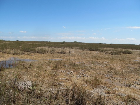 yourself to take in the view! The covered tram is a nice way to avoid the sun and the wind, because there is no shade or shelter for bikers or hikers along the way.
The Observation Tower is at the southern end of the trail, and you should check this out before you turn around and head back north. The tower is made of reinforced concrete and it is ascended via a long walled-in ramp, followed by an open spiral staircase if you want to get to the upper level. The walk alongside the crowds reminded me of filing into a pro baseball stadium on a hot summer day! It is pretty crowded, so we had to wait our turn to get a spot at the front of the wall. Once we did, however, it was a wholly different experience to see the Everglades from above! We were able to watch fish and alligators swimming in the pond below, while birds soared across the plains. The “river of grass” that we had read about became suddenly apparent, in a way that posters and panels could never make clear. Despite the jostling visitors around me, I’ve managed to keep a memory of peace and silence as I looked out across that vista.
 While the view from the Shark Valley tower is impressive, the more fun part of the ride is all the wildlife alongside the trail (note: no sharks). If you have a pair of binoculars, you’ll be able to
 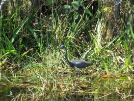 see even more. For the first couple of miles, we stopped every time we saw an alligator or an anhinga, but eventually realized that it would take all day to make the journey at that rate. On the return route, with lighter traffic and more open landscape, we were able to spot more diverse animals around us. For me, the highlights were probably seeing a mother ‘gator with a whole clutch of babies, and watching the feeding behavior of a pair of rare Roseate Spoonbills. Getting to see the ever-changing nature of the ecosystem around me, up close, was also educational.


Much like the experience of seeing the vastness of the landscape first-hand, my understanding of the soil and water interplay in the marsh was significantly enhanced by seeing it laid out before me. Inches of elevation separated wet spots from dry ones, and dictated what types of wildlife used each area. While it may not seem like it from the ground, this area really is a “valley,” one of two main routes that freshwater travels through the Everglades on its way to the sea. Especially in the dry season, the water moves very slowly, too slowly to really see it flow. However, it was clear that local  fluctuations in water level were occurring, because in places the “periphyton” had been lifted off the soil and rock underneath, and caught up in the grasses. This substance is full of life and nutrients for the plants and animals of the prairies and marshes: it is made up of finely crushed sea shells and detritus, and filled with tiny microbes, algae and bacteria. To those of us used to more conventional landscapes, the slow-draining marl soil looks mucky, dirty, even unhealthy. On the contrary, though, it is an indicator of the vibrance of the Everglades and all the life within it!
To sum things up, the Shark Valley trail is a long, flat, reasonably well-paved trail with no shade or wind breaks. It is crowed with tourists and the rental bikes are dodgy. But I promise that you won’t remember any of that (or much of it) after your full journey. Plan to take at least fifteen minutes at the observation tower, and leave the bulk of your time for the return trail heading back north, so that you can stop and observe wildlife and the landscape around you. Bring more water and snacks than you think you’ll need, because it really does get hot out there. Don’t forget the sunscreen! There are toilets at the Observation Tower and Visitor Center, but you’ll need to hold it along the rest of the trail. If you put in a little planning, get an early start (you can leave even earlier with your own bike), and have the right attitude you definitely won’t regret your visit here!


 “big” in Big Cypress refers to the size of the swamp region itself, not necessarily to the trees in it. Bald cypresses can get to be good-sized, but they grow very slowly over their 600 year lifespan, so the girth and height never reach really huge proportions. If you want to check out this particular stand, ask at the Visitor Center for instructions on how to find it (which are something along the line of, “when the trail jogs, keep
 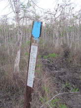 going east until you get to some bigger trees”). While the trail itself is well-marked with Florida Trail posts and periodic blazes, a compass or GPS will be handy if you plan to venture off to find this stand – it is easy to get turned around in the swamp!
 cooler temperatures, they were not extremely active, and I personally thought they were cool to see up close! I don’t know if it was the location, the time of day, or the time of year that brought them there, but if you are not a fan of snakes you might want to ask in the Visitor Center to see if they frequent this trail more than others.


 corresponding change in vegetation around me. The ecology of the region is completely dependent on small changes in water level, so small changes in elevation or holes in the karst bedrock would create different ecosystems within the greater region. I had read about this, and been told about it, but actually walking around in it helped me to understand so much better! Plus, it was cool to actually see and touch these features!
 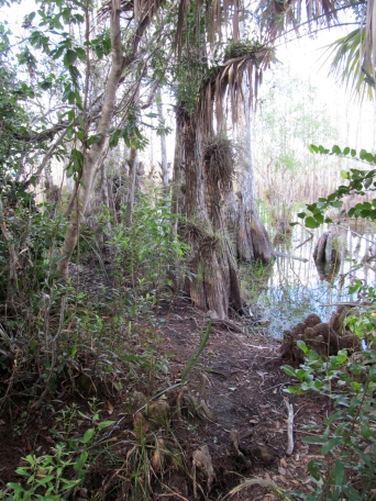 The name alone intrigued me, and I was curious about its separate designation within the Everglades ecosystem, so I decided to investigate. I learned that Big Cypress consisted largely of cypress swamp, that it is the primary range for the last remaining Florida panthers, and that its National Preserve status meant that it was more developed for recreational use than Everglades National Park. What my internet research did not tell me is that the mosquitoes are horrendous! I guess the “swamp” part was supposed to give that away.
 eed a spot that is periodically dry for their seed cones to germinate. During the wet (summer) season, they are inundated by the broad, flat river of water flowing from the north towards the sea, while during the dry (winter) season, patches of dry ground are found within the stands. There are two species in the area: Bald Cypress and Pond Cypress, and both grow either along rivers (called a “strand” of cypress) or in circular patches (called “domes”). Within a cypress dome, the tallest trees grow in the center, and we were taught that the height of the trees roughly mirrors the depth of the water – the tallest trees in the deepest water, while the shortest ones were in shallower areas. Cypress trees grow tall and straight, but they have to have some way to stabilize themselves in mucky soil and changing water levels over their long lives. They grow structures on their lower trunk that look like buttresses, and sprout “knees” all around to help hold themselves up. A final fun fact about cypresses is that they are deciduous conifers – they reproduce via cones, but lose their needles annually and regrow them (maybe why they were named “bald?”).
 The Swamp Walk program, led by a seasonal park ranger, was pretty cool even though group tours aren’t really my thing. The ranger led us off-trail into a cypress dome, talked about ecology, and took us into an alligator hole to see what we could see. We didn’t go that far, but it wasn’t necessarily easy going, as we were standing in water most of the time, sometimes almost waist-deep. The pace was easy, and there was lots of standing-around time as he answered questions for the group.


 At the east end, it became much more developed and our early morning drive coincided with local residents leaving to get to work. This was an interesting reminder of the origin and management of Big Cypress National Preserve. It was created in the 1970s, after residential development had begun, to protect the are from large-scale commercial development. Due to the flat, relatively treeless landscape, there had been plans to construct the largest “jetport” in the world in the middle of this fragile ecosystem, forever disrupting the flow of water and irreparably disturbing the animals and plants that depended on it. When Big Cypress was established, it was done with the cooperation of local residents as well as native tribes, who wanted it to remain open for traditional uses. This is why the park is developed with swamp buggy/ATV trails, airboat trails and campgrounds, is open for regular hunting seasons, and contains both tribal villages and modern western subdivisions in places. Despite this, it feels like a truly wild place, because the annual floods make permanent development or use nearly impossible over most of the vast area. Definitely one to put on your list for exploration!!


 An often-overlooked aspect of Everglades National Park is that about 50% of it is covered with water… but only a few feet. The Ten Thousand Islands is so-called because of the many mangrove islets that dot the tidal flats for over a hundred square miles before giving way to the open Gulf of Mexico. This is an


